[1:TIME]
The thing that distinguishes between a photograph and a film is time. Time perceived as change.
A photograph is an isolated moment, preserved, whilst a film has direction, it documents before and after, through difference. cause and effect.
Instinctively, we know this.
There is a force, on this island, through which time and change become apparent.
Here, the only structures of substantial height are man made. The landscape is low and shallow. It barely lifts out of the sea, and inland, it dips back below to create brackish ponds that have been converted into an oyster farm.
The farm itself sits like a squatting interloper of angles, glass, and metal. It hums constantly because of the pumps that keep the water moving to supply algae to the crustaceans.
The highest point on the island is a lighthouse. It is tall and white. It is a line that bisects the horizon and punctures the deep blue of the sea and the wispy paleness of the sky.
There is a perceived change here. This is animation inferred. I haven't seen the island colonised and constructed, but the presence of these structures makes the change apparent. This is a human timescale measured in, at most, centuries. If you can imagine a camera filming for that long you would see the lighthouse, and the oyster farm, and the warden's cottage, rise up from the ground. Likewise, more temporary structures, like the wooden hides, would rise and fall periodically. Sometimes they would be replaced, other times all that would be left is a slight impression, a footprint where they had been.
Those footprints are visible throughout the reserve. Some are less obvious as nature, adhering to its own time-based forces, begins to overlay itself.
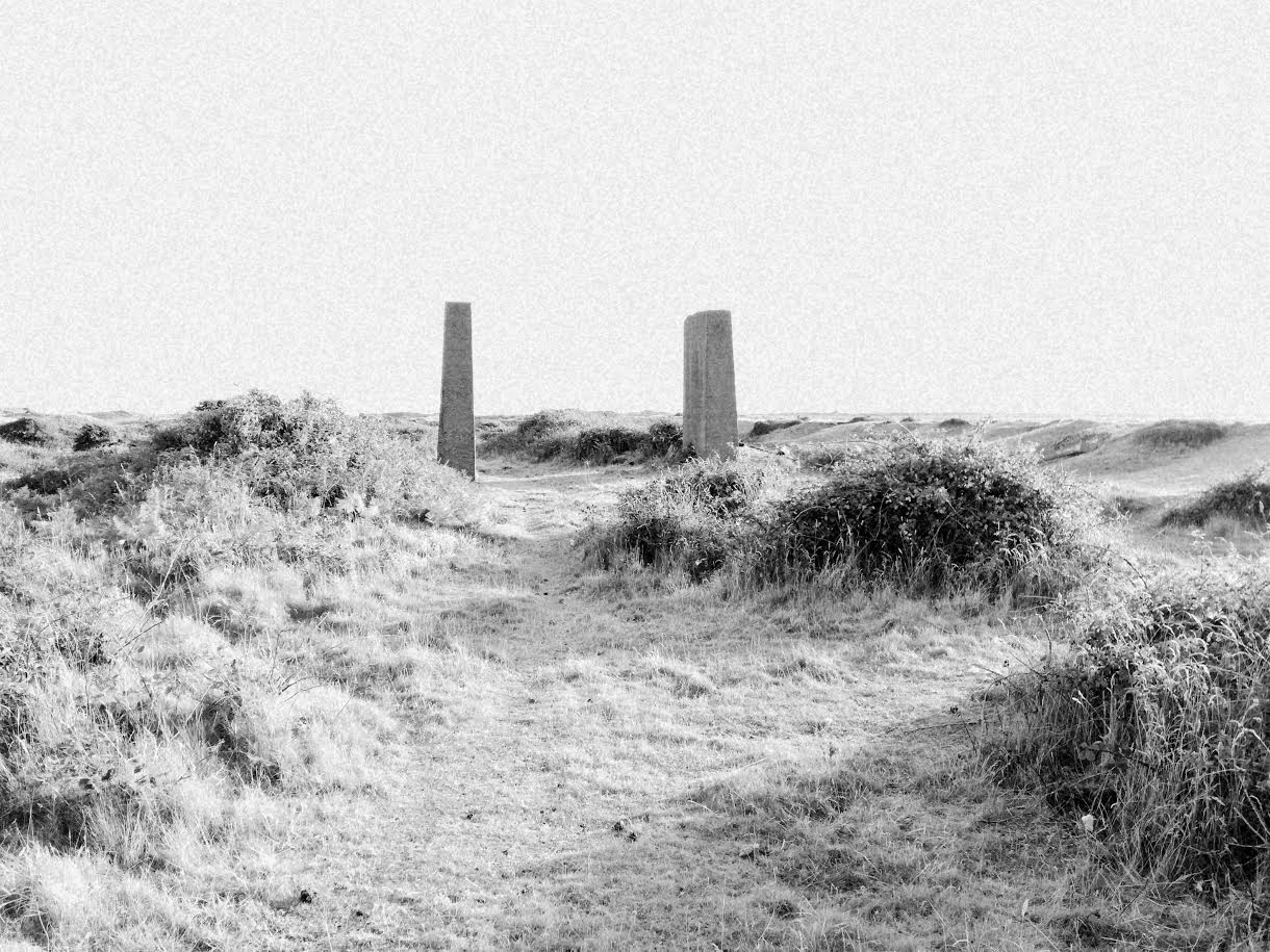
The more obvious structures are large concrete pillars, set upright and apart, like a brutalist Stonehenge. Their ceremonial purpose was to aid in the raising of gravel from the earth. They were once part of a building that belonged to an industry that ended some decades ago. Similarly, skeletal structures still stand monument to the practice of harvesting salt from sea water. Ancient, perpendicular.
Grass has grown around them and birds nest atop them, having found a solution to the problem of ground-based predators.
Closer inspection reveals some more signs of change. In places the ground becomes angular, a symptom of the landscape incorporating large concrete blocks left over from the industry. In among the pools are islands created entirely of right angles. Red brick fragments mingle with the rounded pebbles underfoot.
The main path along the eastern edge of the reserve reveals large iron lines -- train tracks -- only in part as they arise periodically from the beneath the gravel. Elsewhere, chunks of re-mineralised iron can be found, and these can be seen as another element of time and change. The type of circular or chiral time. Iron ore, dug from the earth, is made into iron rails for transport. Left abandoned it slowly returns to its mineralised state and sinks back down into the ground.
In places, it appears that the nature of the island is a recent veneer that has cracked under erosionary forces.
The wind is the primary instigator of change now. On a geological scale it helps to shape the coastline, it arranges the landscape -- piling up sand into dunes, before moving it on again. It covers and it reveals. It is almost always present. the local inhabitants refer to it as the island's main characteristic. It is also the main source of sound here.
It is this agent that animates the island on a more immediate scale, one which we can perceive without history or understanding. Very little remains still. The grass that covers the ground, a way back from the beach, waves constantly.
Nettles and ferns sway.
Gorse rustles.
The island is constantly moving and change is always apparent, and so it becomes a place of animation.
The notion of 'reserve' is one of preservation, or consistency, yet here we find an area that is never still and the only constant is its own movement.
[2:ISLAND]
An island is an area of similarity surrounded by something else, something 'other'.
This is an island -- about 5km2 of land encircled by the Irish sea. It is 18km long and about 2km wide, although those measurements do not adequately describe the strange crescent like shape at the tip of the island. It is a weird quirk that can easily cause disorientation.
The idea of being surrounded suggests that the water must be the 'other'. However, that is not quite the case. The water was here first, unbroken and continuous. It was only at the last glacial period that enough till was deposited at the mouth of the river Duddon, rupturing the waves, that the island of Walney was formed. It is this till -- glacial sediment -- that made the island a fine location for a gravel cast. Here the land is the other. It is an incursion into the water.
The nature reserve at the south of the island occupies 1.3km2 of land. It is also an island, surrounded by a notional other of 'not a nature reserve'. It is difficult to locate this boundry without a map. The reserve consists of salt marsh, shingle, sand dunes and pools of brackish water -- much like the areas that stretch out, north from here. It would be easy to walk quite some distance without realising that you have ventured off the reserve, if it were not for the signs and the cattle-gridded gates.
It wasn't always so. Prior to 1963, this area was just the south of the island. It had its own industry and community. Just as the island found its way into the sea, the reserve found its way into the island.
I have found my way into the reserve.
[3:MAP]
Maps are strange abstractions. Three-dimensional landscapes rendered on a two dimensional surface. Features typified, catagorised and reduced to representational symbols. You need a key to translate them fully. A church with a spire becomes a circle with a cross. Scree is shown as a series of small circles.
And then there are maps that abstract time. There is one here that indicates a battle. If you find your way to this point on the map you will not find the battle, nor traces of it. You may find a commemorative plaque, or an information board. The battle does not exist any more, but it is still noted on the map (abstracted as a pair of crossed swords unlikely in style to be accurate for the date of this battle). This is not just the location of where the battle was fought, but a marker for it happening at all.
We are selective in these markings too. Only certain events are mapped. There have been plenty of scuffles and fights around here throughout history. Why this battle?
The two-dimensional abstraction does not allow events to overlap. This is shown -- brought to the surface -- because it is the dominant one in the narrative.
In a way, all maps are a notation of history. They can only be truly accurate at the moment they are made. Slowly they degrade, becoming less useful as maps and more useful as artifacts.
[4:TIME]
I am stood at the side of a former gravel pit. It is full of translucent algae. A strong current, artificially created by a motorised pump, moves through it. I can see tiny black dots within the mass of green. I believe these are oyster seed.
Close by, there is a tree. Oddly, there is little wind here. The farm lies in a depression created by the gravel excavation, and this bowl seems to be an small island from the wind. The tree, however, stands on the banking. The top pokes out, over the parapet. The evidence of the predominant wind direction is clear -- whilst the branches are motionless and the leaves are barely fluttering, the tree itself is warped and curls back in one direction. It appears like a photograph of a tree caught in a hurricane.
[5: TWILIGHT]
There are many forms of twilight. There is the one before sunrise. There is the one before sunset. They are both forms of anticipation. One marks the start of the beginning of the day, the other marks the start of the end.
And then there is nautical, astronomical and civil twilight. Each of these has specific meanings.
Civil twilight happens when the sun is at 6° below the horizon. Under reasonable conditions it is approximately enough light for the human eye to distinguish between terrestrial objects, rendering outdoor lighting unnecessary for most tasks.
Nautical twilight begins when the sun is at 12° below the horizon in the morning and at 6° below the horizon in the evening. It lacks the symmetry of civil twilight. It also marks the point at which sailors can make reliable calculations on their position as they can see both the horizon and the stars.
Astronomical twilight occurs when the sun is between 12° and 18° below the horizon. Between this twilight in the evening, and its partner in the morning, the sky is completely dark, allowing you to see celestial bodies.
[6:MAPS]
Hervé, the field recordist, heads off in the opposite direction in search of the dawn chorus. I set off in search of the light.
It is before dawn on the 2nd July 2018. It is before 4am at 54.1039°N, 3.2500°W on Walney Island, just west of the town of Barrow. We are in the nature reserve at the southern tip of the island. We are trying to map it.
Hervé is using sound. The birds -- a colony of gulls, oyster catchers, terns. The water -- waves against the shore, the oyster farm water pumps. The wind -- a constant. He is collecting all that is here on the morning of 2nd July, 2018.
I am filming. I have two approaches. The first is the grand landscape. The undulating dunes, the long blue view out into the sea -- in one direction the runined castle on Piel Island, in the other a distant and vast wind farm.
The second approach is to use a macro lens to record the smaller landscapes. The cracks in the rocks, the forests of marsh grass, the bouldered landscapes of the sand grains.
I am also trying to record a 'now', but it is one littered with the past. There are textures of iron and concrete that break up the expanse of gravel and sand. Archaic structures that look like druidic circles, mingle with rabbit warrens. A lighthouse punctures the twilight.
The map we are creating is an abstraction. It is a representation of a space at a particular time. It is fragmented -- isolated parts are held together by a matrix of fact and continuity. Everything is becoming representational. This is not a recording of a specific gull but of 'a gull', this is not a film of a dead rabbit, but 'a dead rabbit'. They are battles. They are crossed swords.
...And from the moment we survey, it is becoming less accurate. It is changing. It is eroding.
[7:PILLARS]
[8:THE WIND]
There is a rhythmical sound, perhaps too subtle to discern, or the wind as it moves cross the borders of water and sand, sand and gravel, gravel and concrete, concrete and grass, grass and sand, sand and water. That sound is the width of this island and the size of its history.